“The main risk we’re looking out for is flooding and coastal erosion. We plan for hurricanes, and major disasters, but as far as we can predict, it’s flooding and coastline erosion.”
This story was originally published by ecoRI News, a publication partner of Ocean State Stories.
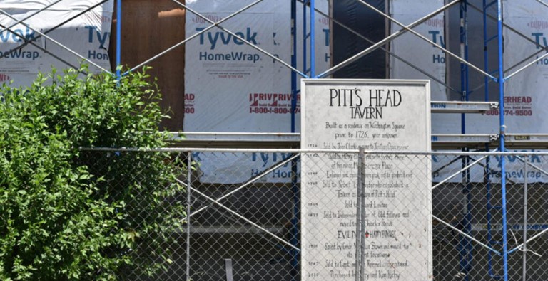
NEWPORT — As it approaches its 300th birthday, the Ebenezer Flagg House, a handsome white colonial with a gambrel roof, proves that old houses can learn new tricks.
Even for a historic home in Newport, the house has had a long history. It was first built sometime before 1726, originally in Washington Square in what was at the time Queen Street. In the 1760s, it was sold and turned into a coffeehouse, giving the building its second name, the Pitt’s Head Tavern, and served as a recruiting headquarters for the British during their occupation of Newport during the Revolutionary War. In the 20th century it served as a time as offices for the Newport Preservation Society.
Besides changing jobs, the building also moved locations twice in the past three centuries, before coming to its final resting place on Bridge Street, in the heart of the Point neighborhood, surrounded by similar, well-preserved, historic colonial homes.
But as the house enters its fourth century, it’s undergoing one other major change, one that more than a dozen and a half historic homes throughout Newport have undergone or are expected to go through sometime in the next few years.
The Ebenezer Flagg House is going to get taller.
“Rising tides are really affecting the Point neighborhood,” said Jeff Emidy, executive director of the Historic Preservation & Heritage Commission (HPHC). “Higher tides are backfilling the drainage system and flooding the neighborhood. The water doesn’t have a place to go.”
The city has a unique problem. On one hand, Newport has the largest and oldest stock of historic homes, buildings, and other structures in Rhode Island, and possibly across the entire Eastern Seaboard, thanks to its long history both as a playground for the nation’s wealthy and an almost-as-long history of historic preservation.
On the other hand, what makes the City-by-the-Sea such a great coastal New England tourist destination also makes it extremely vulnerable to climate change and sea level rise, meaning historic areas, such as Bridge Street, or other neighborhoods close to the shoreline, are going to see more and more flooding as time marches on.
The Coastal Resources Management Council estimates by the end of this century, sea levels in Rhode Island will rise by 8.99 feet. Projections from the National Oceanic and Atmospheric Administration suggest in Newport alone the sea will rise by more than a tenth of an inch annually.
That means more and more of the city’s coastal areas will see increased flooding from the biggest tides, commonly known as king tides. Last year the city experienced nine days where these tides caused flooding, meaning sea levels at least 1.8 feet above mean higher high water (MHHW). According to NOAA projections, by 2030 the city will have 15 days of flooding above MHHW, and by 2050 the number of days will increase to 45.
Newport is one of the few municipalities nationwide to give serious consideration of how to save their stock of historic buildings, many of which are privately owned, from the impacts of climate change and sea level rise.
“The main risk we’re looking out for is flooding and coastal erosion,” said Jillian Chin, preservation planner for the city. “We plan for hurricanes, and major disasters, but as far as we can predict, it’s flooding and coastline erosion.”
Chin, whose background is in cultural and historic preservation, has worked for the past two and a half years in Newport’s Department of Planning and Development. Before that she worked as an architectural historian across the New England region, and one of her daily duties is guiding the city’s historic properties on how best to prepare for climate change.
Newport’s chief response for its historic homes has been creating design standards for homeowners. Originally passed by the city’s Historic District Commission in 2020, it lays out how private homeowners can elevate the foundations of their homes, literally lifting their property above floodwater, while still staying in the well-defined boundaries of historic preservation.
For anyone with experience with Rhode Island’s historic district commissions, it’s surprisingly forward-thinking. Historic districts have a reputation for saying no to most major changes that would significantly alter the character of a historic building within its jurisdiction.
“Newport has a long history of preserving its historic homes,” Chin said. “The city has a history of moving houses. Even before Doris Duke’s work, lots of homes in the colonial era were moved. It was quite common.”
That is how the Ebenezer Flagg House, nearly three centuries after it was first built, will get taller. The building’s owner, a limited liability company called 77 Bridge Street LLC, applied for, and received, a certificate of appropriateness from the Historic District Commission, asking, among other improvements, to raise the structure to meet base flood elevation (BFE) levels, somewhere between 5 and 7 feet.
For the most part, it’s probably nothing too new for historic homeowners. The city’s district commission requires they adhere as close as possible to the original materials of the house when possible and alter as little as the structure as possible.
One snag in the design standards? BFE levels are probably much higher than most historic homeowners would prefer. The flood insurance maps generated by the Federal Emergency Management Agency are, for better or for worse, still the standard by which everything flood lives and dies by. For much of downtown Newport and the Point neighborhood, the minimum BFE level is 12 feet. (The Flagg House applied for a variance to be much lower.)
That’s not even the highest BFE in Newport. For some homes along Ocean Drive and other areas on the southern shore of Aquidneck Island that face open ocean, the elevation requirements can range as high as 18 feet.
“Climate change is a concern for our offices, it’s mentioned in the Statewide Historic Plan as something we want to work on,” Emidy said. “But it’s a balancing act between historic preservation and climate change.”

Rhode Island, thanks to its origins as one of the 13 original British colonies, is awash in historic structures, many of them within FEMA flood zones. A 2016 report from the HPHC showed that 1,971 historic structures across 21 municipalities listed or eligible to be listed on the National Register of Historic Places were in coastal and estuarine flood zones, as mapped by FEMA.
Newport has the lion’s share of historic structures in flood zones. According to the same report, 548 historic structures, over a fourth of the entire list, are within coastal flood zones in Newport. Their estimated combined value at the time was $432.4 million. Vulnerable areas include middle and lower Thames Street, the area around Bowen’s wharf, the Seaman’s Institute, and of course, the Point neighborhood.
Five other municipalities — Bristol, North Kingstown, South Kingstown, Warren, and Westerly — have 100 or more structures in coastal flood zones.
“Owners of historic buildings in harm’s way should endeavor to make their properties more flood resilient to the degree that the historical and architectural integrity is not compromised,” according to the 2016 report. “Property owners may be able to stabilize their flood insurance rates in this way and may realize a reduction over what they would be paying if they did nothing to reduce flood-related damage risk.”
The report also speculated, barring no other actions, rising flood insurance rates would likely spur most historic homeowners to take up these projects, noting, “those buildings that fully meet flood code requirements will have lower premiums than those that do not. If property owners choose to retain their historic buildings and fully meet flood code requirements, they may subject their buildings to upgrades that will compromise their historical and architectural integrity and diminish their community economic value.”
Five years in, Newport’s elevation program is still in its infancy. Chin estimated the total number of historic structures undergoing the elevation process to be somewhere in the high teens, a far cry from the more than 500 historic structures listed in FEMA flood zones.
“They’ve clearly survived this long,” Chin said. “I would say the historic houses are stronger than ever, maybe even stronger than the new houses that are being built now.”